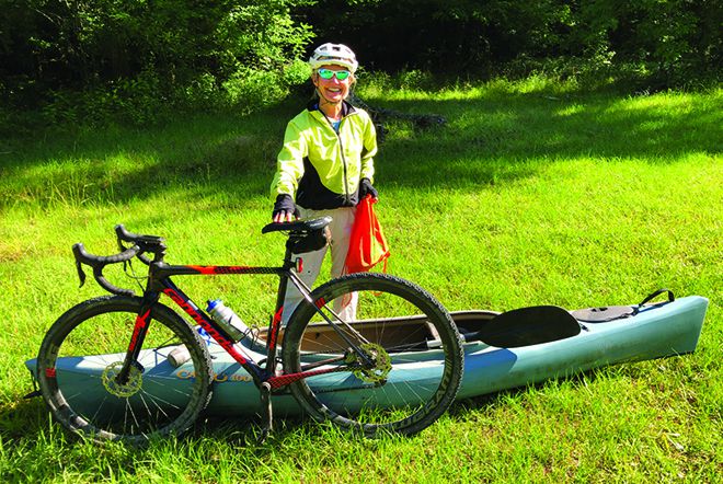
Local Lady Enjoys Ocmulgee Pedal-Paddle
Thanks to The Monticello News<.i>, I recently had a most excellent adventure. In January I read an article about the Georgia River Network offering “Pedal-Paddle” trips in 2021.
These trips have participants ride bicycles to the paddle launch site to avoid putting people together in shuttle buses or vans, thereby limiting exposure during pandemic times. The Georgia River Network then shuttles the bicycles instead of people.
After cycling, my favorite outdoor activity is kayaking. I checked the 2021 Pedal-Paddle schedule and selected the trip on the Ocmulgee River. I loved it. I knew I would.
The Georgia River Network has kayaks for rent, but I used my own. I hauled it in my trailer and put my bicycle in the back of my vehicle. I headed out early to the launch site at the Dodge County public boat ramp, about eight miles north of Abbeville. This was a last-minute change in the starting location due to a bridge that was out, but it was close to the original location, Ochise Landing.
After dropping off my kayak, I drove to Half Moon Landing in Abbeville, our takeout. From there, I rode my bicycle about 11 miles back to the launch site. About 25 people were in our group. As everyone arrived, volunteers loaded our bicycles onto a trailer for transport back to the takeout.
Joe Cook coordinates the Georgia River Network and was our paddling guide. He gave a brief overview of our journey. He also introduced two young women from the Adopt-A-Stream program with the Georgia Environmental Protection Division. Adopt-A-Stream is a citizen outreach program to educate and involve the public in protecting our waters.
These women collected water samples throughout the day to measure pH, dissolved oxygen, macroinvertebrates, and other parameters of stream quality. Finally, we got into the water!
The Dodge County public boat ramp is on a partial oxbow lake. When the river is lower, this site is disconnected from the main Ocmulgee River channel. That’s why the original plan was to launch from the newer Ochise Landing. Fortunately, we had enough flow that day to paddle from the Dodge County ramp.
Joe had us go upstream instead of downstream because the brush is heavier on the downstream end of the oxbow. It was about a half-mile paddle upstream to get to the cut through, i.e., the main river channel. I really hadn’t given much thought to the effort of paddling upstream, but after we turned downstream, it definitely was easier.
While we paddled, I chatted with Joe about Georgia geography. Here’s a fun trivia question he asked me: If you travel on I-16 from Macon to Savannah, you cross five major rivers. What are they? Hint: They form the acronym COOOO (not in that order geographically).
Answer: (geographically from west to east): Ocmulgee, Oconee, Ohoopee, Canoochee, and Ogeechee. I love all the beautiful Native American names.
After a while, Joe asked the group if we wanted to do some exploring. Of course! He led us into the first of several sloughs we paddled through. A slough is a swamp adjacent to the river. Sloughs aren’t accessible when the river is down during the summer. On the other hand, on this trip when the river was sloughs, though. They were magical.
We saw the nest of a yellow-crowned night heron. Sitting quietly, we even caught a glimpse of the beautiful bird in the branches above. Next, we paddled under an arch of tree branches to our lunch spot. We parked our boats on some solid ground between a slough and the main Ocmulgee channel.
While we were there, another paddler made friends with a frog. Fortunately, I had Internet service on the river, which allowed me to use the iNaturalist app on my phone to identify the species as a Cope’s gray tree frog. I’ve become familiar with the call of this frog through a terrific CD, “Calls of the Wild,” produced by the Georgia Department of Natural Resources, Wildlife Resources Division. It was fun to get to see a Cope’s gray tree frog in person.
After lunch we continued downstream and visited another slough. Throughout the day we saw more spectacular plants and animals, including floating marsh pennywort, cypress trees and knees, an anhinga (also known as a snakebird), baby herons, and a (nonvenomous) brown water snake.
Toward the end of our paddle, we passed the former site of Poor Robin’s Ferry. On May 8, 1865, Confederate President Jefferson Davis crossed the Ocmulgee at this location, then known as Brown’s Ferry. Two days later the Union Army, believing that Davis was complicit in the April 15 assassination of President Lincoln, captured him about 26 miles southwest of Abbeville.
Even surrounded, Davis attempted to flee under the cover of his wife’s overcoat but was quickly apprehended. Northern newspapers reported his capture with much hyperbole, depicting the incident with Jefferson in a wig and hoop skirt.
Just off of the river lies Poor Robin Spring. The spring pumps water from the Floridan aquifer. It once was a recreation site, but today a company owns it that produces bottled spring water. We paddled close enough to step out onto the embankment and view the bright blue water.
Every time I paddle, I wonder why I don’t do it more often. And how great to get to explore a portion of the Ocmulgee River I hadn’t been on before! I marveled at its astonishing beauty and how seemingly few people know about the wonderful treasure we have in our Georgia rivers. If you’d like to enjoy and protect our waters, check out and support the Georgia River Network, www.garivers.org.