Helicopters to fly low in northeast Missouri counties for aquifer study
PROTECTED CONTENT
If you’re a current subscriber, log in below. If you would like to subscribe, please click the subscribe tab above.
Username and Password Help
Please enter your email and we will send you a password reset link.
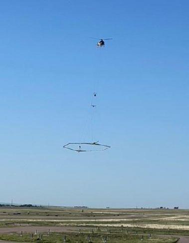
Photo Courtesy of Aqua Geo Frameworks, LLC
The Missouri Geological Survey will be working with SkyTEM to conduct helicopter flights in northeast Missouri as part of an aquifer study in Clark, Scotland, and Schuyler counties.
The Missouri Department of Natural Resources’ Missouri Geological Survey will be conducting a study in northeast Missouri’s Clark, Scotland, and Schuyler counties to identify possible underground aquifers. The goal of this study is to find sources of groundwater to assist landowners in locating favorable water well construction sites, which may provide solutions to negative drought impacts on the region’s water supply.
To complete this study, three separate projects will be conducted in the three counties. Beginning approximately Oct. 19, residents may see a low-flying helicopter towing a large hexagonal frame. MGS is contracting with SkyTEM and Aqua Geo Frameworks LLC to conduct these airborne surveys. This technique has previously been used for mapping of glacial aquifers in Nebraska, Iowa, North Dakota, Indiana, and Illinois.
The scientific equipment hangs about 100 feet below the helicopter in a spider web array and is designed to map geologic structures and groundwater resources down to approximately 900 feet below the land surface. The helicopter will be flown by pilots who are specially trained for low-level flying and the flight paths are designed to get the best available underground data. The helicopters are flown by LiveWire Aviation of Homosassa, Florida. Since data can only be collected over open spaces, no data collection will occur over residential areas, livestock feeding operations, or other buildings. After the flights, Aqua Geo Frameworks LLC will use the data to produce a 3D hydrogeological framework and final report for MGS.
The helicopter company operates under FAA unlimited part 135 unscheduled air-taxi operations, part 133 a,b,c and d external loads, and part 137 agriculture dispersal.
As part of this project MGS staff will be collecting passive seismic data throughout the three counties. Data will be collected via placement of a device on the ground to collect seismic readings from natural vibrations in the subsurface. Both the seismic survey and airborne survey will measure the thickness and type of materials left by glaciers following the Ice Age. These glacial deposits overlie the bedrock in much of northern Missouri. Areas with higher sand and/or gravel content are more likely to hold groundwater and be suitable for well construction.
A third phase of the study will involve the drilling of geologic test holes to collect subsurface data. The material collected from the holes will be used to validate the airborne and passive seismic data. The passive seismic and drilling tasks will be completed on public lands, primarily road right-a-ways.
Questions regarding the airborne surveys can be directed to Jared D. Abraham, Aqua Geo Frameworks, LLC, at jabraham@aquageoframeworks.com and 303-905-6240.
Additional information about the overall project, passive seismic, or geologic drilling can be directed to Scott Kaden, Missouri Geological Survey, at scott.kaden@dnr.mo.gov and 573-368-2194.